September 12, 2026
Cartagena is the walled colonial port on Colombia’s Caribbean coast, a city of just over a million people at sea level, where the most extensive fortifications in South America, a colonial center that UNESCO listed in 1984 and a beach holiday sit a taxi ride apart, and the place most first trips to Colombia either start or end. It is also the city where the heat, the vendors and the prices catch more visitors out than anywhere else in the country, mostly because they read guides written by people who came once in January. We run nine tours in and around Cartagena, from a private morning through the walls before the heat to our own boats to the Rosario Islands, and we put guests in cars from the airport every week, so this is the guide we give our own travelers before they land: what the city is and how to read it, where to stay by neighborhood, what is worth your time and in what order, how to get in and around, the heat and the rain in plain terms, safety with the city’s own numbers, how Cartagena compares with Santa Marta, and the shape of two, three or five days.
The short version
Give Cartagena three nights, four if you want a day on the water and a day on the road. Sleep inside the walls or in Getsemaní if the city is the point, in Bocagrande or Castillogrande if a pool and a beach are; either way the center is on foot and everything else is a fixed-fare taxi. Plan the days by the heat, not the map: the walls and the Castillo de San Felipe at seven in the morning, the museums and the food in the middle of the day, the sunset from the walls or from a boat, Getsemaní after dark. Do the beaches on the islands, not in the city, and go on a boat that leaves from an authorized dock. Check the museum days before you plan a Monday, and the calendar before you book a hotel in a festival week. Wear no gold, agree every price before you sit down, and save the district’s WhatsApp line for the bill that is five times what it should be. Then decide whether the next stop is Santa Marta and the mountains, which is the other half of this coast.
Where Cartagena is, and what it is
Cartagena de Indias sits on the Caribbean coast of Colombia, about 670 kilometers north of Bogotá in a straight line by the coordinates, at sea level: the IDEAM’s station at the airport is two meters up. It is the capital of the department of Bolívar and one of the country’s special districts, the Distrito Turístico y Cultural de Cartagena de Indias, a status the 1991 Constitution preserves in its article 328 alongside Santa Marta and Barranquilla. The full name, Cartagena de Indias, is the one that tells it apart from the Cartagena in Spain, and it is pronounced car-ta-HEH-na, with the g before the e sounding like a hard h and the stress on the third syllable. Colombia keeps one legal time all year, five hours behind Coordinated Universal Time under Decreto 2707 de 1982, with no seasonal change, so the clock in Cartagena matches New York in the northern winter and runs an hour behind it in summer. By road, Barranquilla is 109.9 kilometers away on the new dual carriageway along the coast and about two hours, and Santa Marta about 230 kilometers and four to five hours; both are in Safe Transfers‘ route pages, since that is the company of ours that drives them.
The bay was sighted in 1501 by Rodrigo de Bastidas and the city was founded in 1533 by Pedro de Heredia on the site of a Carib village called Calamarí, the word for crab, by the Instituto Cervantes’ guide to the city; the city celebrates its founding on June 1. For its first half century it had no stone defenses at all, which is why Francis Drake could sack it in 1586, and the walls, the bastions and the Castillo de San Felipe that followed were built over two centuries against exactly that: the belt of walls was finished in 1796 and runs eleven kilometers by ProColombia’s figure, and in 1741 the fort held against the English admiral Edward Vernon, who came with more than 170 ships and 26,000 men and had struck medals in advance reading “I took Cartagena”. On November 11, 1811, Cartagena declared absolute independence from Spain, forced by the militia of Getsemaní; in 1815 the Spanish reconquest under Pablo Morillo besieged the city for 105 days and about ten thousand people died of hunger and disease rather than surrender, which is why the city’s title is La Heroica. In 1984 UNESCO inscribed the Port, Fortresses and Group of Monuments of Cartagena as World Heritage, 192.32 hectares in three sectors, the Centro, San Diego and Getsemaní, and called the fortifications the most extensive in South America.
By the DANE’s latest projections, published by the district in August 2025, Cartagena reached its peak population in 2025 with 1,011,520 people and begins to shrink slowly from 2026, when it has 1,010,995; the projection has the city back under a million by 2033 and at 974,086 by 2042, close to where the 2018 census found it. It is also the country’s cruise port: the cruise terminal on the Manga side of the bay receives 97 percent of the passengers who reach Colombia by ship, by the port’s own figure, and the airport, Rafael Núñez, handled 7,756,298 passengers in 2025, a record, of whom 1,752,903 were international, by the figures in our airport guide.
Reading the city: the walls, the bay and the peninsula
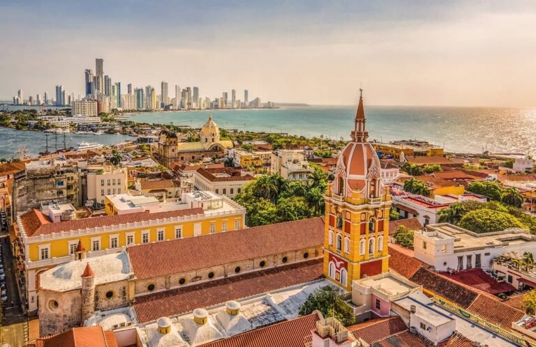
Cartagena is easy to read once you see that it is four or five small cities a taxi ride apart. The colonial city is the walled center on a point between the open sea and the Bahía de las Ánimas, with the Puerta del Reloj, the clock-tower gate, as its front door; it is about a kilometer across, divided into the Centro around the Plaza de Bolívar, with the plazas, the restaurants and the noise, and San Diego, the quieter northern half toward Las Bóvedas. Right behind the gate is Getsemaní, the neighborhood of one-story houses and painted walls that was outside the walls when the walls mattered and is where the city eats, drinks and dances now, with the Plaza de la Trinidad 500 meters from the gate. East of both, behind the Castillo de San Felipe on its hill, the residential island of Manga and the neighborhood of Pie de la Popa sit two kilometers from the gate; south across the bay the peninsula of Bocagrande runs three kilometers into the sea, a strip of apartment towers and hotels on a beach, with Castillogrande on its bay side and El Laguito at its tip; and north the seafront of El Cabrero, Marbella and Crespo runs 4.4 kilometers to the airport, and beyond it La Boquilla, a fishing village, and the resort hotels of the Zona Norte on the road toward Barranquilla. The islands, Tierra Bomba across the mouth of the bay, Barú with Playa Blanca, and the Rosario Islands an hour out, are the beach half of the trip. The walled center plaza by plaza is in our Walled City guide, the neighborhood behind the gate in our Getsemaní guide, and the whole geography with every distance and every taxi fare in our guide to where to stay. The hotel peninsula, from its name to its beach after the 2026 works, is in our Bocagrande guide.
Where to stay in Cartagena, neighborhood by neighborhood
For the colonial city at the door, the walled center: the Centro for the plazas and the restaurants, San Diego for the same streets with quieter nights, in colonial houses built around a patio, the most expensive beds in the city and the ones most people picture. For the nights, the hostels and the cheaper boutique hotels, Getsemaní, five minutes from the gate on foot and louder than the center after dark. For a pool, a beach in front of the hotel and families, Bocagrande and Castillogrande, ten minutes by taxi from the center, with the sea in front and a taxi ride to every dinner. For quiet, Manga, residential and leafy behind the fort. For a late arrival or an early flight, the seafront of Marbella, El Cabrero and Crespo, the cheapest fixed taxi zone from the airport. For a resort with the city as a day trip, the Zona Norte beyond La Boquilla; and for a night with the sea at your feet, Barú or the islands, with the park’s rules and a boat to come back on. Whatever you choose, check that the lodging holds a Registro Nacional de Turismo, which the law requires of every hotel, hostel and short-term rental in Colombia, and ask whether the rate for a foreign visitor is exempt from the 19 percent IVA, because for most non-residents it can be; the two rules, with the law behind them and a free lookup for the registry, are in our where-to-stay guide, which names no hotels and takes no commission.
What to do in Cartagena, in the order we would do it
The order is the heat’s. At seven in the morning the walls are empty and the stone is still cool: walk the circuit from the Puerta del Reloj along the sea to Las Bóvedas and you have seen the shape of the city in an hour, and the Castillo de San Felipe, the great fort on the hill of San Lázaro, opens at seven every day, 38,000 pesos for a foreign adult under its 2026 tariff, and is a place for the tunnels and the ramparts before nine, with someone who can explain them. The middle of the day belongs to the plazas and the museums, six of them inside the walls with 2026 hours and prices in the Walled City guide, and to the food: the arepa de huevo and the fritos from the morning carts, the sweets of the Portal de los Dulces, the fish and coconut rice at lunch. Sunset lands between roughly a quarter to six and half past six all year and the walls face it; the famous spot is the Baluarte de Santo Domingo, the same view with fewer people is the stretch north toward Las Bóvedas, and the best of all is from the water. After dark, Getsemaní: the Plaza de la Trinidad fills from about seven with neighbors on the church steps, carts and music, and the bars on the Calle de la Media Luna and the Arsenal run until late. The second day is the water, the third is the road, and the things we skip, the party bus, the beaches inside the city as the main event and Bazurto market without a guide, are in our guide to things to do in Cartagena, hour by hour.
Our own days in the city are built on that order. The private city tour is six and a half hours that start before the heat, San Felipe, the walled city plaza by plaza and Getsemaní with a guide who lives here, from 158 US dollars per person for two; the food walk of the walled city is four private hours and five tastings, from 155; the Getsemaní and San Felipe walk is three hours on foot from the Plaza de la Trinidad, from 55; the private graffiti tour is two and a half hours among the murals with the politics behind them, from 56; and the private sunset boat is three hours on the bay with your own captain and crew, from 200. All prices are per person for two travelers, as the tour pages show them.
After dark the city changes shape, and the honest version of where the night happens, what time it ends and the bill to watch for is in our Cartagena nightlife guide.
The calendar: which day for what
Two of the six museums inside the walls close on Mondays, the Museo del Oro Zenú and the Museo de Arte Moderno, and two do not, the Palacio de la Inquisición and the Museo Naval; the Castillo de San Felipe opens every day of the year. Playa Blanca on Barú is at its best on a weekday, because everyone in the city can now drive there on weekends and holidays, and the islands are at their best early, before the shared boats from the Muelle de la Bodeguita arrive. The district’s own high-season calendar, published for the electric carriages and true for the hotels, is December 15 to January 15, Holy Week, July and August, the recess week in the second week of October and the Fiestas de Independencia in the first half of November, which in 2026 run from the 1st to the 15th with the Gran Desfile on November 12 and the Cabildo de Getsemaní on the 14th, by the district’s program. On top of that, three festivals fill the walled center’s hotels months ahead: the Cartagena Festival Internacional de Música, January 9 to 17, 2027, the Hay Festival, January 28 to 31, 2027, and the film festival FICCI, April 6 to 11, 2027; and Barranquilla’s Carnaval, two hours up the coast, falls on February 6 to 9, 2027 by the dates the newspaper El Heraldo published, which we mark as press until the organization posts its own calendar. The rainy months, May to November with October the wettest, are the cheap ones, and the rain is an afternoon storm rather than a lost day; the month-by-month numbers are in our Cartagena weather guide.
The day trips: the Rosario Islands, Barú, El Totumo, Palenque and Barranquilla
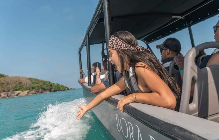
The Rosario Islands are the day almost everyone should take: an hour by boat from the city, a national park, the Corales del Rosario y de San Bernardo, with living coral to snorkel over at Playa Grande, the floating bars of Cholón for the two hours you can stand them, and Playa Blanca on Barú for the afternoon. The day costs the boat plus the park’s entrance fee, 13,500 pesos per person for the Rosario sector under the tariff published at the start of 2026, plus the mandatory accident insurance every visitor has needed since March 1, 2026, plus lunch on the beach; go privately if you can, because the boat then leaves before the wind and the crowds and the day belongs to you, or on a shared boat from the Bodeguita if the budget says so, and know that the schedule is theirs. What the islands actually are, hour by hour, is in our Rosario Islands guide, and every beach the city has, from the grey sand of Bocagrande to the Blue Flag at La Boquilla, is in our beaches guide. Playa Tranquila, around the coast from Playa Blanca on the same stretch of Barú, is the beach we take families to. El Totumo, the mud volcano an hour inland where you float in the mud and rinse in the swamp, pairs with an afternoon on Manzanillo beach. San Basilio de Palenque, an hour and a half inland, is the first free town in the Americas, founded by Africans who escaped Cartagena’s slave port under Benkos Biohó, still speaking its own creole and recognized by UNESCO in 2005, and it is the best thing near Cartagena that most visitors never see. And Barranquilla, 109.9 kilometers up the coast, is a stop on the way to Santa Marta for most people and a destination for the four days of its Carnaval.
We run each of these as a private day with hotel pickup: the Rosario Islands on our own boat, eight hours with your captain and crew, from 349 US dollars per person for two; Playa Tranquila and the aquarium, eight hours, from 163; El Totumo and Manzanillo, seven hours with lunch, from 138; and San Basilio de Palenque, seven hours with a guide from the town and a homemade lunch, from 172.
Getting in and getting around
Rafael Núñez airport is inside the city, in the neighborhood of Crespo, 4.4 kilometers from the clock tower, and it runs 24 hours with one terminal for domestic and international flights. From the official taxi stands the fare is fixed by zone under the district’s 2026 decree: 20,200 pesos to Getsemaní and the Marbella and Cabrero seafront, 24,300 to the Muelle de la Bodeguita by the clock tower, 28,500 to Manga, 34,400 to Bocagrande, Castillogrande and El Laguito, with 1,100 more at night from 7 p.m. to 5 a.m.; ride apps pick up outside the terminal; the Transcaribe T102 bus stops a street away for 3,900 pesos with a card; and a private transfer with the driver waiting inside the terminal starts at 49 US dollars with Safe Transfers, our transfer company. The whole tariff, Check-Mig, Biomig and the currency question are in our airport guide. Cruise ships dock at the terminal on the Manga side of the bay, 3.2 kilometers from the historic center by the port’s own figure, a ten-minute taxi ride from the walls. Long-distance buses use the Terminal de Transporte on the Carretera de la Cordialidad at the eastern edge of the city, open since May 1, 1994, roughly ten kilometers from the walls in a straight line and a taxi ride rather than a walk from anything a visitor uses.
Inside the city you walk: the walled center and Getsemaní are on foot, and a rental car inside the walls is a liability. Between the neighborhoods you take a taxi, which in Cartagena runs on the district’s fixed fares by zone rather than a meter, so ask the fare before you get in and expect the airport figures above as the reference, or a ride app, which works well across the city. Transcaribe, the bus system, runs its T102 trunk line along the seafront from Crespo to the Chambacú and Centro stations at the edge of the walled city, and it is the cheapest way from the airport if you have no luggage and the patience. Boats leave from the authorized docks, the Muelle de la Bodeguita for the shared boats and the marinas and nautical clubs that the maritime authority lists for the private ones; a boat from anywhere else has no passenger list filed behind it, which is why we do not use them. To Santa Marta, four to five hours east on the Troncal del Caribe through Barranquilla and across the Isla de Salamanca park, and to Barranquilla, about two hours, we send guests by private car; the routes, the tolls and the honest comparison with the shared shuttles are on Safe Transfers’ pages for Cartagena to Santa Marta and Cartagena to Barranquilla.
The heat and the weather, in plain terms
Cartagena is hot every day of the year and the only question is whether it is also wet. The IDEAM’s normals for 1991 to 2020 at the airport put the daily high between 31.1 degrees in January and February and 32.3 in June, the low between 24.0 and 26.1, and the humidity around 80 percent in every month; the difference between the seasons is rain, not temperature. From December to April it barely rains at all, 0.5 millimeters in January, 0.3 in February, with the trade wind blowing from December to March and the sea at its roughest; the rains begin in May, 117 millimeters, and run to November, with October the wettest month at 236.5 millimeters on twelve rainy days and a brief lull in June. The total is 1,073.8 millimeters on 70 days a year, and the rain, when it comes, is an afternoon storm that floods the low streets of the old town for an hour and clears. What this means for a day is that the walls and the fort are for seven in the morning, the museums are for the heat, the sea breeze on the walls at sunset is the best air of the day, and in October you bring the shoes you do not mind getting wet. The month-by-month table, the sea’s calendar and the hurricane question are in our Cartagena weather guide.
Is Cartagena safe?
Yes, for the trip on this page, with rules that are simple and local. What reaches tourists, in order, is overcharging on the beaches and in the bars, snatch theft of gold chains and phones in the Old City and Getsemaní, drink-spiking and dating-app robberies, unlicensed taxis and boats, and swimming where boats run; what almost never reaches them is the violence in the numbers, which the police’s own figures place in the city’s poorer districts, between armed groups and their rivals: 153 homicides between January and June 2026 against 201 in the same months of 2025, a fall of 23.9 percent, with 144 of the city’s neighborhoods recording none at all. So: wear no gold, agree every price before you sit, watch your drink, book cars and boats from authorized places, take a taxi rather than a walk between neighborhoods after the bars close, and save the district’s Titán Chat, a WhatsApp line on +57 304 251 1127, open 24 hours and in several languages, where you can ask the official price of anything and report a bill while you are still sitting at the table. The neighborhoods as they are, the cases behind each rule and the advice for women, solo travelers, families and LGBTQ travelers are in our guide to whether Cartagena is safe.
Cartagena or Santa Marta, honestly
They are the two halves of the same coast, 230 kilometers apart, and the honest answer is that most trips of a week or more should do both, in that order. Cartagena is the colonial city: the walls, the plazas, the museums, the restaurants, the nights in Getsemaní, and islands an hour away by boat; it is hotter and wetter, 1,074 millimeters of rain a year to Santa Marta’s 562 by the IDEAM’s normals at the two airports, more expensive, and more crowded. Santa Marta is the oldest city in Colombia and the door to the Sierra Nevada: Tayrona National Park, the village of Minca in the cool hills above the city, Palomino at the end of the road, the four-day trek to the Lost City, and a city that is a base rather than a destination in itself. If you have three or four nights on the coast and want a city, Cartagena; if you want the jungle, the mountains and a beach with a national park behind it, Santa Marta; if you have a week, three nights in Cartagena and four in Santa Marta, with the private car between them on the fourth morning. Our guides to Santa Marta and Tayrona cover the other half; our Colombia itinerary puts the two together in seven, ten and fourteen days.
How many days, and the shape of them
Two days cover the city: one for San Felipe, the walled center and Getsemaní, the other on the water at the Rosario Islands or Playa Blanca. Three days add Palenque or El Totumo, or a slow morning in San Diego and an afternoon at Playa Tranquila. Five days add a night on an island or in Barú and a day for the beaches and the sunset boat, and by the fifth day you have understood why people come back. A cruise day, ten minutes from the walls, is the city tour before the heat and the food walk in it. The shape that works, whatever the length, is the same: streets and fort early, museums and food at midday, the walls or the water at sunset, Getsemaní at night, and one full day on a boat that leaves from the right dock.
What we do differently, and what we cannot promise
We live and work on this coast, and the difference shows in the order of things: the fort at seven and not at noon, the museums on the right day, the boat that leaves before the wind, the beach we take families to instead of the famous one, and a car between the neighborhoods after dark. Every tour of ours in Cartagena is private unless the page says shared, runs in English or Spanish, and most include hotel pickup in the Old City, Getsemaní and the peninsula as standard. What we cannot promise is a dry October afternoon, a calm sea on a January morning when the trade wind is up, a quiet night over the Media Luna, or a Cartagena without vendors; what we can promise is that the city, given three days and the right order, is for us the most beautiful colonial city in the Americas and one of the best-run trips we sell, and that the numbers on this page were checked on September 12, 2026 and will be checked again.
Questions travelers ask
Where is Cartagena?
On the Caribbean coast of Colombia, in the north of the country, about 670 kilometers north of Bogotá in a straight line and 230 kilometers by road from Santa Marta; a short domestic flight from Bogotá and Medellín, with international flights into its own airport and a cruise terminal ten minutes from the walls. It is the capital of the department of Bolívar.
What time is it in Cartagena?
Colombia keeps one time zone all year, five hours behind Coordinated Universal Time, under Decreto 2707 de 1982, with no daylight-saving change: the same as New York from November to March and one hour behind it the rest of the year.
Is Cartagena safe for tourists?
Yes, with the rules: no gold on the street, every price agreed before you sit, drinks watched, cars and boats from authorized places, a taxi rather than a walk between neighborhoods after the bars close. Homicides fell 23.9 percent in the first half of 2026 by the police’s figures and are concentrated far from the areas on this page; what reaches visitors is overcharging and snatch theft.
Is Cartagena worth visiting?
Yes, for three nights at least. The walled center is a World Heritage site whose fortifications UNESCO calls the most extensive in South America, the islands are an hour away by boat, and the food and the nights in Getsemaní are, for us, the best on the coast. It is hot, crowded in the high season and full of vendors, and it is still worth it.
How many days do you need in Cartagena?
Three nights: a day for the fort, the walled center and Getsemaní, a day on the water at the Rosario Islands, and a third for Palenque, El Totumo or a slow day in the city. Two nights work if you only want the city; five if you want a night on an island as well.
Where should I stay in Cartagena?
Inside the walls or in Getsemaní if the point is the colonial city, Bocagrande or Castillogrande if the point is a pool and a beach, Manga for quiet, the seafront near the airport for a layover. The distances, the taxi fares and the two rules to check before you book any lodging are in our where-to-stay guide.
How many people live in Cartagena?
About 1,011,000 in 2026 by the DANE’s latest projections, published by the district in August 2025; the city peaked in 2025 and is projected to shrink slowly to about 974,000 by 2042, close to the 2018 census count.
How do you pronounce Cartagena?
Car-ta-HEH-na, with the g sounding like a hard h and the stress on the third syllable; locals say Cartagena de Indias when they need to tell it apart from the Cartagena in Spain, and La Heroica when they are being proud of it.
Plan it with us
Nine tours in Cartagena and its day trips, most of them private with hotel pickup, all of them run by the people who wrote this page; our transfers from Rafael Núñez and our cars to Santa Marta and Barranquilla are operated by Safe Transfers by Cielo.Travel. Write to us on WhatsApp with your dates and where you are staying, or start with our Cartagena tours and the rest of our Colombia guides.
Sources
The facts on this page were checked on September 12, 2026 against the following sources: the Constitución Política de Colombia, article 328, in the Función Pública’s Gestor Normativo, for the district’s status; the Alcaldía de Cartagena’s notice of August 13, 2025 on the DANE’s population projections; UNESCO’s listing 285 for the World Heritage inscription; the Instituto Cervantes’ guide to Cartagena de Indias for the founding; Fortificaciones Cartagena de Indias, the Escuela Taller’s site, for the title of La Heroica, the fort’s history and its 2026 tariff; the Alcaldía’s electric carriages page for the high-season calendar; the Puerto de Cartagena for the cruise terminal; the Terminal de Transporte de Cartagena for its location and opening date; the Superintendencia de Industria y Comercio for Colombia’s legal time; the IDEAM’s climatological normals 1991 to 2020 on datos.gov.co for the Rafael Núñez and Simón Bolívar stations; the Cartagena Festival Internacional de Música, the Hay Festival and FICCI for their 2027 dates; El Heraldo for the 2027 Carnaval dates (press, non-authoritative); and our own Cartagena guides to the walled city, Getsemaní, where to stay, things to do, the beaches, the Rosario Islands, the airport, the weather and safety, each sourced in place, for the museums’ 2026 hours, the park’s fee and insurance, the airport’s passenger figures and taxi tariff, the police figures and the Fiestas program; the road figures are Safe Transfers’ route pages, from the national concession’s figures for Barranquilla and from the press and toll directories for Santa Marta. Distances are calculated from coordinates.