September 13, 2026
The short version
Santander is the department where Colombia goes to be outdoors. Three hours south of Bucaramanga and six or seven north of Bogotá, a river has cut a canyon two kilometres deep, and the towns along its rim have spent the last twenty years learning to sell what that canyon makes possible: rafting, paragliding, caving, rappelling down waterfalls, and walking a stone road the Guane people laid before any Spaniard saw it.
Two places anchor it. San Gil is the working town — 1.114 metres, 24 degrees, the Alcaldía’s own figures, and the place every operator and every hostel is based. Barichara is twenty minutes away and is the reason half the photographs of Colombia you have seen exist: a town of stone and lime declared a national monument in 1975, and a Pueblo Patrimonio since 2010.
If you read one paragraph, read this one. Come between December and February, when the rain almost stops. Sleep in Barichara and use San Gil for the activities rather than the other way round. Give it three days if you want the canyon and the town, two if you only want the town. And know that the drive from Bogotá is long enough that flying into Bucaramanga and driving down is usually the better trade.
Where Santander is, and what it is made of
Santander sits in the eastern Andes, between Boyacá to the south and Norte de Santander to the north. Its capital is Bucaramanga. The part travellers come for is the south of the department — the provincia de Guanentá, whose capital is San Gil — where the Chicamocha river has spent several million years cutting downward.
The Cámara de Comercio de Bucaramanga, the region’s own chamber of commerce, puts the Cañón del Chicamocha at an average depth of about two kilometres and a length of 227 kilometres, reaching its deepest between the municipalities of Aratoca, Cepitá, Los Santos and Jordán. Downstream the Chicamocha meets the Fonce and the Suárez and becomes the Sogamoso. You will see the claim that it is deeper than the Grand Canyon on a great many signs and brochures. It is a promotional line rather than a measured comparison, and we are not going to repeat it.
What matters for a trip is simpler. The canyon is enormous, it is dry, it is hot at the bottom and temperate at the top, and every activity in the region is arranged around either its rim or the rivers that feed it.
San Gil, honestly
San Gil is not a pretty town. It is a busy provincial one, built around a plaza with a very old ceiba tree in it, and it exists in the traveller’s mind because of what is arranged from it rather than what is in it. The Alcaldía’s own site calls it the capital turística de Santander — the tourism capital of Santander — and that is the accurate claim. You will also read that it is the adventure capital of the world. That is marketing, and no official body says it.
The numbers, from the municipality: 1.114 metres above sea level, an average of 24 degrees with a maximum of 32 and a minimum of 15, 149,5 square kilometres, 96 kilometres from Bucaramanga and 327 from Bogotá. The Fonce is its river.
What you actually do in San Gil is book things. Rafting on the Fonce and the Suárez is what the town is best known for; we do not run it, so we are not going to put grades and prices on it that we cannot stand behind. What we do run from here is everything in the rest of this guide.
The one thing worth doing in the town itself is the Parque El Gallineral, a river island of trees hung with moss, which takes an hour and is pleasant rather than remarkable. Eat in the market. Then leave for the day and come back.
Barichara, and why it looks like that
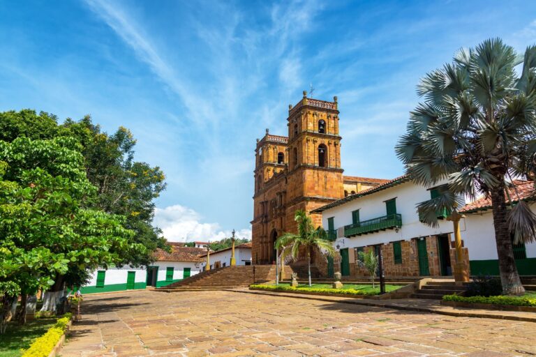
Barichara was founded on 29 January 1705. Its historic centre was declared a national monument by Resolución 005 of 30 June 1975 and registered by Decreto 1654 of 3 August 1978, and it has been part of Fontur’s Red Turística de Pueblos Patrimonio since 2010, which is the network’s own record. The nickname came first, in May 1975 by the Alcaldía’s own account, and Fontur’s page for the town still uses it: el pueblito más lindo de Colombia, the prettiest little town in Colombia, and for once the slogan is doing very little work.
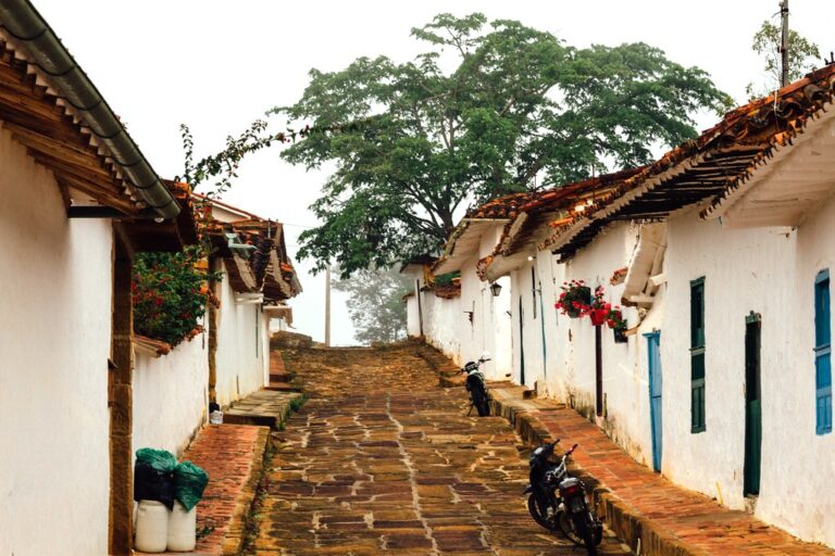
The reason it looks the way it does is geological rather than architectural. The hillside Barichara stands on is soft sandstone that splits into flat blocks, and the town is built out of the ground it stands on — walls of cut stone and rammed earth, streets paved in the same stone, and the whole town the same colour because it came from the same quarry. The technique has a name locals will use with you, piedra rajada, split stone.
It is small. You can walk every street in two hours. The things to actually stop at are the cathedral on the main plaza — the Templo de la Inmaculada Concepción, begun by Martín Pradilla y Ayerbe, who is buried in its presbytery, and held up by ten monolithic stone columns — the Capilla de Santa Bárbara at the top of the town with the view down the Suárez valley, and the cemetery, which is more interesting than that sounds. The Alcaldía puts the town at 1.336 metres and its urban average at 22 degrees in a range of 19 to 28, two degrees cooler than San Gil.
A practical note that changes trips: Barichara is where you should sleep. It is twenty-four kilometres from San Gil by the Alcaldía’s own figure, it is quieter, it is cooler, and waking up in it is the single best part of a Santander itinerary. Most people do the opposite, base themselves in San Gil, and see Barichara for three hours in the middle of a hot afternoon, which is the worst time to see it. The town itself — the church and its ten columns, the crafts, what the management plan actually forbids, and the walk down to Guane — has its own guide: Barichara, Colombia.
The Camino Real to Guane
From the edge of Barichara a stone path drops through the Suárez canyon to the hamlet of Guane. It is the best single thing to do in Santander and it costs nothing but a morning.
The road is pre-Hispanic in origin — the Guane people laid it, and the Spanish paved and extended it. The Camino de Guane is a Bien de Interés Cultural of national scope, declared by Resolución 790 of 31 July 1998, and the Ministerio de Cultura’s management plan for it protects seven kilometres of the road at a total width of eighteen metres. The stretch you actually walk from Barichara down to Guane is shorter than the protected extent: El Tiempo’s culture desk gives it as 5,5 kilometres and two to two and a half hours downhill, and adds a restoration in 1988 — press figures, marked as such, because the article attributes them to no government body.
What is not in question is what it is like. It is downhill the whole way, in the open, on uneven stone, with the canyon widening in front of you. Guane at the bottom is a plaza, a church, a small palaeontological museum with marine fossils from when this was all seabed, and a bus back up. Start at seven. By ten the stone is hot and there is no shade to speak of.
Do not walk it uphill unless you specifically want to. There is a bus from Guane back to Barichara and everybody takes it.
Getting here is a long drive from anywhere. Bogotá transfers has the road north on one page with the booking widget on it, and the Colombia transfers hub has the airport run from Bucaramanga.
The canyon and the cable car
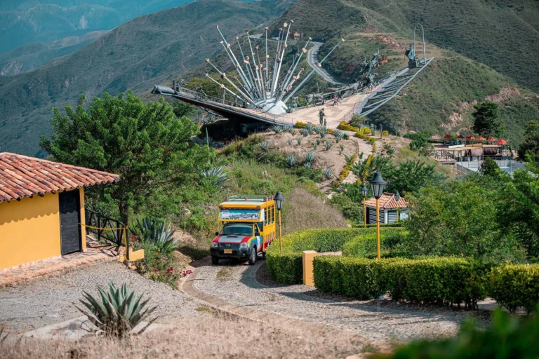
The Parque Nacional del Chicamocha, which everyone calls PANACHI, sits on the rim of the canyon about fifty minutes from Bucaramanga on the road down to San Gil. It is a theme park on top of one of the great views in South America, and how much you enjoy it depends on making peace with that sentence.
The thing to do there is the cable car. It is 6,3 kilometres long by the park’s own figure, carries up to 500 people an hour, and it does not skim the canyon — it goes down one wall, crosses the river, and climbs the other side, which takes roughly half an hour each way and is the reason to come.
The park’s 2026 prices, from its own site, in Colombian pesos: the Panachi combo that includes the park, the aquapark and the cable car is 108.000 for an adult and 79.000 for a child of two to eight; park and aquapark together 65.000 and 55.000; the park alone 58.000 and 43.000. Individual attractions run from 4.000 for the children’s farm to 250.000 for a paragliding flight. It opens Wednesday to Friday from 10:00 to 18:00 and on weekends and holidays from 09:00 to 18:00, and the cable car runs in four windows: 10:30 to 11:00, 12:30 to 13:00, 14:30 to 15:00 and 16:00 to 17:00.
Read that last line again, because it is the thing that ruins visits. The cable car is not continuous. If you arrive at 13:30 you are waiting an hour. Prices and timetables change; check the park’s own site before you travel.
Flying over it
Paragliding in the Chicamocha is the other way to see the canyon, and it is a genuinely different experience from the cable car. You launch from the rim, and the canyon does the rest — the thermals coming off two kilometres of hot rock are what make this one of the more reliable flying sites in the country.
It is a tandem flight with a pilot. You do not need experience and you do not need to be fit. What you do need is a morning with stable air, which in practice means going early and accepting that a flight can be called off for wind. Any operator who will fly you in any conditions is not one to fly with.
Juan Curi, Pescaderito and the water
Two places do the swimming, and they are different in character.
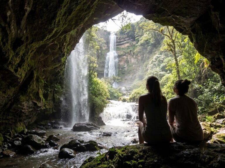
Juan Curi is a waterfall in a private reserve about half an hour from San Gil, with a pool at the bottom you can swim in and a rappel down the face for people who want that. It is the one that appears in photographs. It also involves a walk up to reach it, which is short but steep and, in the wet months, slippery.
Pescaderito, just outside Curití, is a string of natural pools in a stream — five of them, walkable one to the next, with rock to sit on and no infrastructure to speak of. It is where people from San Gil go on a Sunday. It is less dramatic than Juan Curi and considerably more pleasant to spend an afternoon at.
Curití itself is worth the twenty minutes: it is a fique-weaving town, and the workshops are real ones rather than displays.
What the weather actually does
Santander is drier than most of Andean Colombia and the difference between months is large enough to plan around. The Alcaldía de Barichara gives the reason: the Serranía de los Cobardes stands between the town and the Magdalena valley, and the humid air coming off the river loses its water trying to cross it, so what reaches the mesa is dry and almost cloudless.
IDEAM’s 1991–2020 normals for the Hacienda el Mamonal station in San Gil give an annual 1.181,4 millimetres on 139,5 days of rain. January is the driest month at 16,6 millimetres on 2,6 days; May is the wettest at 160,4 on 17,1 days, with August close behind at 148,0 on 17,7. The Alcaldía’s own rainfall range for the municipality, 600 to 1.800 millimetres with an average of 1.200, agrees with the station.
Barichara, at the Santa Isabel station, is drier again: 1.038,3 millimetres a year on 107,6 days, January 27,3 on 2,8 days, October the wettest at 137,3. That is thirty-two fewer rainy days a year than San Gil, twenty minutes away, which is a real difference and not a rounding one.
One caveat worth stating, because most sites do not. Neither station measures temperature — the normals carry rainfall and rain days for these municipalities and nothing else — so the temperatures in this guide are the municipalities’ own figures, 24 degrees for San Gil and 22 for Barichara. Neither station is in its town either: San Gil’s sits at 1.408 metres above a town at 1.114, and Barichara’s at 1.300 metres below a town at 1.336.
In practice: December, January and February are the dry window and the right time to come. April to May and September to October are the two wet peaks. The heat at the bottom of the canyon is a separate matter from the rain and does not vary much — it is hot down there all year.
The risk, stated plainly
Santander is not a place with a security problem for visitors, and the open data says so rather than us.
The national police publish homicides and theft by municipality through datos.gov.co. Both series currently run to 31 July 2026, so the only honest comparison is January to July against January to July. On that basis: Barichara, Aratoca and Curití recorded no homicides at all in either 2025 or 2026. San Gil went from one to five, which is a real rise and still a very small number in a town of its size.
The crime that actually reaches travellers is theft of persons, and there the direction is the other way. San Gil fell from 87 in the first seven months of 2025 to 64 in the same months of 2026. Barichara went from six to seven, Aratoca from five to two, Curití three and three. These are towns where a bad week moves the annual figure.
What that means on the ground is ordinary care and nothing more: phone away on the San Gil plaza at night, bag in front of you at the bus terminal, and the usual rule about not walking rural roads after dark. The genuine risks in Santander are the ones you sign up for — moving water, a slippery stone road, and a canyon rim — and they are managed by going with people who will call a day off when conditions are wrong.
One clarification worth making, because the names catch people out: Santander and Norte de Santander are two different departments. The United States State Department’s Colombia advisory of 31 March 2026 places the country at Level 3, Reconsider Travel, and lists four regions as Do Not Travel — Arauca, Cauca excluding Popayán, Valle del Cauca excluding Cali, and Norte de Santander, which is the one on the Venezuelan border. Santander, the department this guide is about, is not among them.
Getting there, and getting around
There are two ways in and they are not close in quality.
Through Bucaramanga. Fly into Palonegro, drive south. The Alcaldía gives San Gil as 96 kilometres from Bucaramanga; allow two to two and a half hours, because the road drops into the canyon and climbs out of it and you will want to stop at the rim. This is the route we use and the one we would recommend to anybody.
From Bogotá by road. 327 kilometres by the municipality’s figure, and six to seven hours in practice. It is a long day, and the last stretch is good road. It only makes sense if you are already driving north or you are combining Santander with Villa de Leyva.
Once you are there, distances are short: San Gil to Barichara is about twenty minutes, San Gil to Curití about twenty, San Gil to the canyon rim about an hour. Local buses connect all of it and are cheap and slow. What a driver buys you here is the early start, which on the Camino Real and on a paragliding morning is the whole difference.
Where to stay
Sleep in Barichara. We have said it twice and we will say it again, because it is the single change that most improves a Santander trip. The town has small hotels and restored stone houses, it is quiet after dark in a way San Gil is not, and it is a degree cooler.
Stay in San Gil if your trip is built around rafting and early river starts, or if you are travelling on a hostel budget — San Gil has the hostels and Barichara largely does not.
Guane and Curití are day trips, not bases. Whatever you book, check that the property is registered in the Registro Nacional de Turismo; a legitimate Colombian hotel will have an RNT number and will show it.
When to come, and for how long
Two days gets you Barichara properly and the Camino Real to Guane. That is a real trip and many people should just do that.
Three days adds the canyon — the cable car, or a flight over it, or both.
Four days adds the water: Juan Curi, or Pescaderito and Curití, and an afternoon with nothing in it.
On timing, December to February is the dry window and the best of the year. Holy Week and the two weeks after Christmas are when Colombians travel, so Barichara fills and prices rise; if you want the town empty, come in a dry January week that is not the first two. The wet peaks in April and May and again in September and October do not make the region impossible, but they make stone paths slick and they can ground a flight.
What a Santander day actually costs
Two numbers do most of the work here, and they are very far apart.
The canyon park is the expensive fixed cost and it is fixed by the park, not by us: 108.000 Colombian pesos for an adult on the combo that includes the cable car, 58.000 if you only want the park. Those are the park’s 2026 prices from its own site.
Everything else in the region is cheap. The Camino Real costs the bus fare back from Guane. Pescaderito costs nothing. Curití costs whatever you spend on fique. Barichara costs a coffee and a set of stairs.
Our own Santander tours, per person with two travelling, run from 87 dollars for the Camino Real to 192 for the quad day, with the canyon and the paragliding in between at 180 and 182. What you are buying there is a private driver and a guide, hotel pickup and an early start — which on a stone path in the sun and on a flying morning is worth more than it sounds.
Pairing it with Villa de Leyva
If you are driving between Bogotá and Santander, Villa de Leyva is on the way and the two make an unusually good pair. Both are colonial towns built in stone, both are dry, and they are different enough that you do not feel you have seen the same thing twice: Villa de Leyva is a vast flat plaza in a desert basin, Barichara is a small town falling down a hillside.
The sensible shape is Bogotá, two nights in Villa de Leyva, then north to San Gil and Barichara for two or three more, and out through Bucaramanga by air. That turns a long drive into a route instead of a transfer, and it is the itinerary we would build if you asked us for a week in the east.
What to bring
Santander is hot, dry, bright and made of stone, and most people pack for the wrong one of those.
Shoes with grip matter more than anything else. The Camino Real is uneven stone for five and a half kilometres downhill and the streets of Barichara are the same surface. Sandals are the single most common mistake.
Then: sun. There is very little shade on the Camino Real, none at all on the canyon rim, and the light at 1.100 metres is stronger than it feels. Hat, sunscreen, and more water than you think.
Layers for the evening are worth a small corner of the bag — the towns cool off after dark in a way the canyon floor does not. And if you are flying, wear something you do not mind sitting down in.
Questions travellers ask
Is San Gil or Barichara the better base? Barichara, unless your trip is built around rafting. It is quieter, cooler and much more pleasant to wake up in. San Gil is twenty minutes away and that is where the activities leave from anyway.
Can I do Santander as a day trip from Bogotá? No. It is six to seven hours each way by road. Two nights is the practical minimum.
Is the cable car worth it if I am afraid of heights? It is a long, slow, fully enclosed cabin crossing a very deep canyon. If heights are a real problem for you, the rim viewpoints give you most of the view with none of the crossing.
Do I need to be fit for the Camino Real? It is downhill for five and a half kilometres on uneven stone. You need decent shoes and working knees rather than fitness, and you need to start early for the heat.
What about rafting? It is what San Gil is known for and it is not something we run, so we will not describe conditions we have not checked. Any hostel in San Gil will book it.
Plan it with us
We are a Colombian company and Santander is a day’s drive from our Bogotá base. Every tour on this page is private, with a driver and a guide who work for us, and pickup from where you are staying.
If you want the shape of it from someone who has done it: two nights in Barichara, the Camino Real on the first full morning, the canyon on the second, and a slow afternoon in the town before you drive back. Tell us when you are coming and we will build the rest around it.
Sources
Alcaldía de San Gil (geography, altitude, temperature, area, distances, rainfall); Alcaldía de Barichara (altitude, temperature range, distances, founding date, the 1975 resolution and the 1978 decree, the church, and the Serranía de los Cobardes); Fontur, Red Turística de Pueblos Patrimonio (Pueblo Patrimonio since 2010); Ministerio de Cultura, Resolución 688 de 2015 as modified by Resolución 3961 de 2019 (Decreto 1654 de 1978 for Barichara’s historic centre, Resolución 790 de 1998 for the Camino de Guane, and the seven kilometres by eighteen metres the plan protects); Parque Nacional del Chicamocha, the park operator’s own site (2026 prices, opening hours, cable car length and timetable); Cámara de Comercio de Bucaramanga (canyon depth, length and municipalities — a trade body, not a government source); IDEAM 1991–2020 climatological normals via datos.gov.co, stations Hacienda el Mamonal in San Gil and Santa Isabel in Barichara; Ministerio de Defensa open data via datos.gov.co for homicides and theft of persons by municipality, both series to 31 July 2026; United States Department of State, Colombia travel advisory of 31 March 2026 (advisory level and the Do Not Travel list); El Tiempo for the Camino Real’s walking length, walking time and 1988 restoration, marked in the text as press because the article cites no official body. Prices, timetables and opening hours change; check them before you travel.